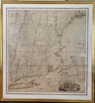
A Map of the most Inhabited Part of New England containing the Provinces of Massachusets [sic] Bay and New Hampshire, with the Colonies of Conecticut [sic] and Rhode Island, Divided into Counties and Townships; The whole composed from Actual Surveys and its Situation adjusted by Astronomical Observations.
London. Thomas Jefferys, November 29th, 1772. copper-engraved map, four sheets joined, approx. 104.5 x 98cm, [ 41" x 38.5"]., original outline colour; minute loss at few folds; with two detailed insets, one of the city of Boston and the other of Boston Harbour; with the large cartouche depicting the Pilgrims.....