![Item #37523 [From]. Shores of The Polar Sea. A Narrative of The Arctic Expedition of 1875-6. Illustrated by Sixteen Chromo-lithographs and numerous Engravings. Edward L. - Sixteen Chromolitho Plates MOSS.](https://mcgahernbooks-ca.cdn.bibliopolis.com/pictures/37523_1.jpg?width=768&height=1000&fit=bounds&auto=webp&v=1612042711)
![[From]. Shores of The Polar Sea. A Narrative of The Arctic Expedition of 1875-6. Illustrated by Sixteen Chromo-lithographs and numerous Engravings.](https://mcgahernbooks-ca.cdn.bibliopolis.com/pictures/37523_2.jpg?auto=webp&v=1612042711)
[From]. Shores of The Polar Sea. A Narrative of The Arctic Expedition of 1875-6. Illustrated by Sixteen Chromo-lithographs and numerous Engravings.
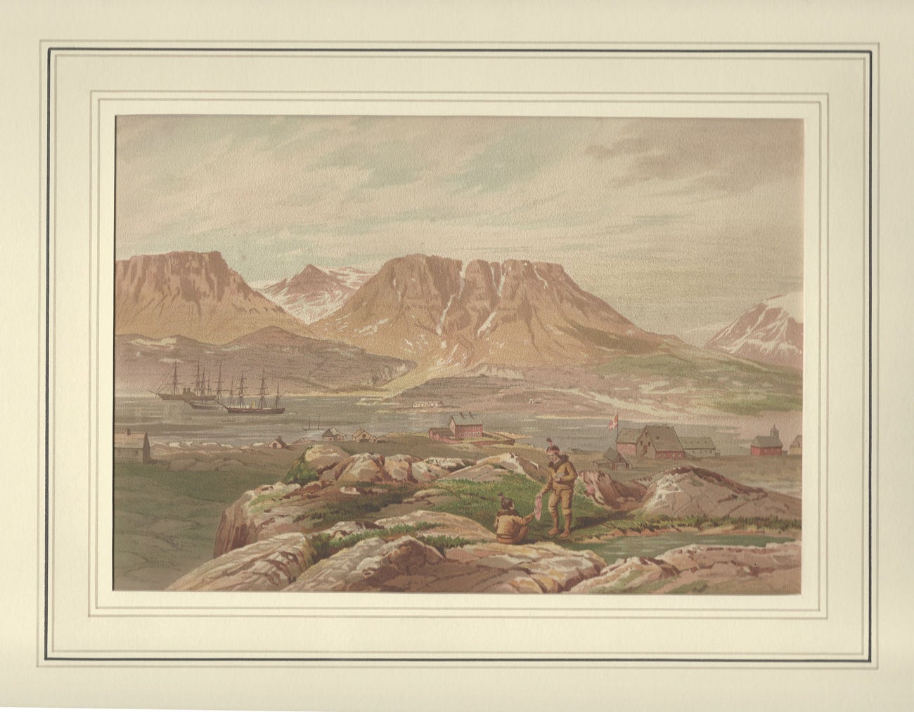
London. Marcus Ward & Co. 1878. Imperial folio, 48x33cm The British Expedition 1875-76: H.M.S. Alert, commanded by Captain G. S. Nares (the Expedition leader) and H.M.S. Discovery (Captain H. F. Stephenson) entered Smith's Sound at the end of July 1875 and after much difficulty with pack ice both ships reached Lady Franklin's Bay where H.M.S. Discovery was established in Winter Quarters whilst the Alert pressed on northwards and reached the edge of the heavy ice named the "Paleocrystic Sea" by Nares, the ice floes being 80-100 feet thick. Leaving Robeson Channel the vessel made progress between the land and the grounded floe pieces and passed the Winter off the open coast and facing the great polar pack, in 82' 27' North. Autumn parties were despatched in September and October to lay out depots and during the Winter plans were laid to explore as much of the unknown area as possible by the combined efforts of sledging parties from both ships in the ensuing Spring, The parties set out at the beginning of April 1876: Captain Markham with Lieutenant Parr advanced, in the face of great difficulties, over the Polar pack to the latitude 83 degrees 20 minutes North. Lieutenant Aldrich explored the coastline to the Westward, facing the frozen Polar ocean for a distance of 220 miles. Lieutenant Beaumont made discoveries of great interest along the Northern coast of Greenland. The expedition returned to Britain in October 1876 the Alert having reached a higher latitude and wintered further North than any other ship had ever done before. The results of the expedition were the discovery of 300 miles of new coast line, the examination of part of t.he frozen polar ocean, a series of meteorological, magnetic and tidal observations at two points further North than any such observations had ever been taken before, and large geological and natural history collections. - Godhavn Harbour, Disco Island, July 10th 1875. - Foulke Fiord and the Island of Greenland. July 28, 1875. - Musk Ox Hunt, Discovery Harbour. Midnight August 25, 1875. Floeberg Beach and the Polar Sea, looking North from the crest of Cape Rawson. July 1876.- Winter Quarters, Outside, from the Floes astern of H.M.S. Alert. December, 1876. - The Deck: Morning inspection and prayers. - Winter Quarters, Inside H.M.S. Alert-The Wardroom. - Lunar Haloes.- The dawn of 1876. H.M.S. Alert in Winter Quarters. - Unidentified.- Winter Quarters, from amongst the Floebergs, looking South. March, 1876. - A Floeberg, Simmon's Island. April, 1876. - On the Northern march. April 8, 1876. - The most Northern grave. June, 1876. - Back from the farthest North - The last of the Paleocrystie Floe, Kane's open polar sea, Cape Constitution, Franklin and Crozier Islands in the distance. August 20, 1876. 16 chromolithographs all approximately 7.3/4" by 11" inches (19.7 by 27.9 cms.) after drawings made on the spot by Dr. Edward L, Moss. In wash line matts and in fine condition. (cgc). Item #37523
Price: $3,500.00 save 25% $2,625.00