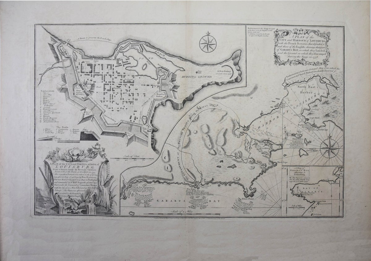
![Item #37724 A Plan of the City and Harbour of Louisburg, with the French Batteries that defended it, and those of the English, shewing that part of Gabarus Bay, in which they Landed, and the Ground on which they Encamped during the Siege of 1758. [on one sheet with]. A Plan of the City and Fortifications of Louisburg; from the survey made by Richard Gridley, Lieut. Coll. of the Train of Artillery in 1745, This important Fortress was when on the 17th of June 1745, after a Siege 49 Days by Nine Regiments (that were Raised & Equiped in 50 Days in New England), and commanded by Sr Willm. Pepperill, assisted by a Fleet under the Command of Conmodore Warren, with the loss of 101 Men killed, and 30 that died by Sickness. This Place was afterwards restored to. Thomas - MAP. JEFFERYS, LOUISBURG.](https://mcgahernbooks-ca.cdn.bibliopolis.com/pictures/37724_1.jpg?width=768&height=1000&fit=bounds&auto=webp&v=1612455161)
A Plan of the City and Harbour of Louisburg, with the French Batteries that defended it, and those of the English, shewing that part of Gabarus Bay, in which they Landed, and the Ground on which they Encamped during the Siege of 1758. [on one sheet with]. A Plan of the City and Fortifications of Louisburg; from the survey made by Richard Gridley, Lieut. Coll. of the Train of Artillery in 1745, This important Fortress was when on the 17th of June 1745, after a Siege 49 Days by Nine Regiments (that were Raised & Equiped in 50 Days in New England), and commanded by Sr Willm. Pepperill, assisted by a Fleet under the Command of Conmodore Warren, with the loss of 101 Men killed, and 30 that died by Sickness. This Place was afterwards restored to
London. Printed for Robert Sayer. & Thoms. Jeffers. [1758]. 38x 62cm, (15"x 24.5"), overall 55x 74.5cm, (21.5"x 29.5"), very good to fine condition. Kershaw 908, "Third State". Armstrong #25. Listed under Richard Gridley. Few maps anywhere manage to combine surveying, military, and historical information as successfully as this map. (Armstrong). An important map published in "Jefferys. The Natural and Civil History of the French Dominions in North and South America". The map was originally published on October 9, 1758 and is a composite of two plans of the Fort of Louisbourg and one inset map of the Bay of Garbarus. The first plan describes the successful 45 day siege of Louisbourg by the British that ended on June 17, 1745. The siege was comprised of nine regiments raised and equipped from New England under the command of Sir William Pepperill and supported by a fleet headed by Commodore Warren. Louisbourg would eventually be returned to the French as part of the Treaty of Aix la Chapelle in 1748. It has been argued that the siege of Louisbourg in 1745 "was one of the most important battles of King George's War, the North American conflicts of the War of Austrian Succession between Britain, France, and Spain." Item #37724
Price: $5,000.00 save 25% $3,750.00