![Item #40719 A Map of the most Inhabited Part of New England containing the Provinces of Massachusets [sic] Bay and New Hampshire, with the Colonies of Conecticut [sic] and Rhode Island, Divided into Counties and Townships; The whole composed from Actual Surveys and its Situation adjusted by Astronomical Observations. MAP, Thomas JEFFERYS, Braddoock alias John GREEN MEAD.](https://mcgahernbooks-ca.cdn.bibliopolis.com/pictures/40719_1.jpg?width=768&height=1000&fit=bounds&auto=webp&v=1670007152)
![A Map of the most Inhabited Part of New England containing the Provinces of Massachusets [sic] Bay and New Hampshire, with the Colonies of Conecticut [sic] and Rhode Island, Divided into Counties and Townships; The whole composed from Actual Surveys and its Situation adjusted by Astronomical Observations.](https://mcgahernbooks-ca.cdn.bibliopolis.com/pictures/40719_2.jpg?auto=webp&v=1670007152)
![A Map of the most Inhabited Part of New England containing the Provinces of Massachusets [sic] Bay and New Hampshire, with the Colonies of Conecticut [sic] and Rhode Island, Divided into Counties and Townships; The whole composed from Actual Surveys and its Situation adjusted by Astronomical Observations.](https://mcgahernbooks-ca.cdn.bibliopolis.com/pictures/40719_3.jpg?auto=webp&v=1670007152)
![A Map of the most Inhabited Part of New England containing the Provinces of Massachusets [sic] Bay and New Hampshire, with the Colonies of Conecticut [sic] and Rhode Island, Divided into Counties and Townships; The whole composed from Actual Surveys and its Situation adjusted by Astronomical Observations.](https://mcgahernbooks-ca.cdn.bibliopolis.com/pictures/40719_4.jpg?auto=webp&v=1670007152)
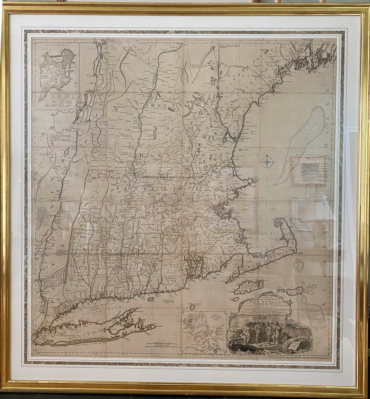
A Map of the most Inhabited Part of New England containing the Provinces of Massachusets [sic] Bay and New Hampshire, with the Colonies of Conecticut [sic] and Rhode Island, Divided into Counties and Townships; The whole composed from Actual Surveys and its Situation adjusted by Astronomical Observations.
London. Thomas Jefferys, November 29th, 1772. copper-engraved map, four sheets joined, approx. 104.5 x 98cm, [ 41" x 38.5"]., original outline colour; minute loss at few folds; with two detailed insets, one of the city of Boston and the other of Boston Harbour; with the large cartouche depicting the Pilgrims arriving at Plymouth Rock in 1630. A lovely example of this scarce map, some detail wear on the frame, beautifully matted and framed but, rare. Item #40719
Cumming. British Maps of Colonial America, pp45-47. McCorkle. New England in Early Printed Maps, 774-4. Stevens & Tree. Comparative Cartography, 33 (e). This is the fifth state of this work, which was first published in 1755 and updated periodically thereafter; this map was in Jefferys' posthumous (and notoriously scarce) American Atlas of 1775. Thomas Jefferys (1719-71) was a leading British cartographer and publisher; Braddock Mead c.1688-1757, a.k.a., John Green, was an Irishman who was imprisoned in Ireland on grounds of fraud, took on his alias when he was released, and moved to London. He became an extremely practiced and professional cartographer, and held his profession to the highest level. This map contains family names of real estate holders, as well as cartographic details of the New England states from the latitude of 44'30 in the north to Long Island Sound in the south, encompassing part of Maine, Rhode Island, what is now Vermont, New Hampshire, Massachusetts, northern Connecticut, and eastern New York from north of Crown Point through Lake George and down the Hudson River. One of the most important of North American maps, this version was published shortly before the Revolution.
Price: $19,000.00 save 25% $14,250.00